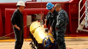
For nearly two years, boats dragging high-tech detection devices across the Indian Ocean have failed to solve the mystery of the whereabouts of Malaysia Airlines Flight 370.
But in December one boat raked up a different one — a shipwreck some 200 years old at the bottom of the sea.

“An anomalous sonar contact was identified in the course of the underwater search, with analysis suggesting the object was likely to be man-made, probably a shipwreck,” said the Joint Agency Coordination Centre, the Australian agency directing the search for MH370, the Boeing 777 that mysteriously disappeared in March 2014 en route from Kuala Lumpur, Malaysia, to Beijing.
Searchers sent out a second boat, Havila Harmony, this month to take a picture using the sonar on board an autonomous underwater vehicle, the agency said in its latest operational report.
They showed the image to experts at the Shipwreck Galleries of the Western Australian Museum who said the wreckage is probably a ship made of steel or iron from the early 19th century.
Previous 1800s shipwreck
The discovery may have been a déjà vu for searchers. In May, they found another shipwreck from the 1800s.
As with the new find, they also took images using high-resolution sonar. These revealed an anchor and parts of a destroyed hull at a depth of 3,900 meters (12,795 feet).
Some of the shipwreck’s shinier debris initially piqued searchers’ interest as possibly being pieces of MH370. But the plane eluded them once more.
The only debris strongly believed to be from the airliner found so far washed up in July on France’s Reunion Island in the Indian Ocean. A series of numbers found inside a plane flaperon matched records held by a Spanish company that manufactured portions of the component, linking the debris to MH370, the Paris prosecutor’s office said.
‘Good night Malaysian three-seven-zero’

In the early hours of March 8, 2014, Malaysia Airlines Flight 370 took off from Kuala Lumpur International Airport in Malaysia headed to Beijing, with 239 passengers and crew on board.
At 1:19 a.m., as the Boeing 777-200ER was flying over the South China Sea, Malaysian air traffic controllers radioed the crew to contact controllers in Ho Chi Minh City for the onward flight through Vietnamese airspace.
The crew’s acknowledgment of the request was the last thing ever heard from MH370: “Good night Malaysian three-seven-zero.”
Shortly afterward, air traffic controllers in Malaysia lost contact with the plane somewhere over the sea between Malaysia and Vietnam.
Malaysian authorities revealed later that military radar had tracked the plane as it turned back to the west and flew across the Malaysian Peninsula, up the Strait of Malacca, before flying out of radar range at 2:14 a.m. and vanishing.
Two-thirds done
Searchers have slowly scoured 80,000 square kilometers (nearly 31,000 square miles) of the Indian Ocean seafloor so far in search of the plane, the Joint Agency Coordination Centre said in its latest operational report.
That’s an area nearly as large as South Carolina, according to the U.S. Geological Survey.
Searchers plan to comb 120,000 square kilometers (more than 46,000 square miles, an area larger than Ohio) and should be done by midyear.
“In the absence of credible new information that leads to the identification of a specific location of the aircraft,” the agency said, “governments have agreed that there will be no further expansion of the search area.”
If MH370 is found and is reachable, the wreckage will be recovered.
As reported by CNN
